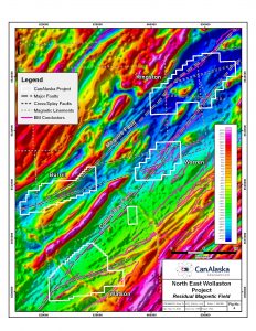
Location
The NE Wollaston projects consist of four claim groupings totalling 29,671 hectares, located 60 kilometres northeast of Cameco’s Rabbit Lake mill and Eagle Point mine (Figure 1).
![]()
Geology
The project areas cover the Collins Bay Fault, host to the Rabbit Lake, Collins Bay A, B and D, and Eagle Point orebodies, beyond the edge of the Athabasca Basin and within the Western Wollaston Domain supercrustals (psammites, pelites, graphitic pelites and calcsilicates). In addition, the drill-proven Maguire Fault with Athabasca-type basement alteration systems and mineralization, trends into the project areas. The Collins Bay Fault and the Maguire Fault, in association with newly defined and interpreted splay and cross-structures are the focus of the claim-holdings. This structural interplay is critical for the deposition of basement-hosted uranium deposits.
Sandstone remnants described in the Pinkham Lake area (Figure 1) northwest of the project area support the interpretation this region was once covered by Athabasca Group sandstone and that the paleo-unconformity is sufficiently close to the present topographic surface to provide exploration potential for basement-type targets such as Eagle Point, Millennium and Arrow. Basement deposits such as Eagle Point and Arrow have been shown to reach depths of 900 metres below the unconformity providing added exploration space beyond the margins of the Athabasca Basin.
Exploration Methodology
Throughout the Western Wollaston Domain, long linear structures develop within graphitic metasedimentary sequences. These large structures are known to be key for the focus of uranium-bearing fluids and formation of high-grade uranium orebodies and deposits in and around the Athabasca Basin. Important areas of fluid focus occur where these long linear structures are architecturally upgraded due to bends or flexures along their length, splay structure development, or cross-structure intersection. These structural complexities allow open space to develop, uranium-bearing fluids to penetrate and interact with the graphitic rocks, and uranium to precipitate in large quantities. The identification of structurally complex areas along these structures is critical in exploration methodology for the Athabasca Basin unconformity-related model.
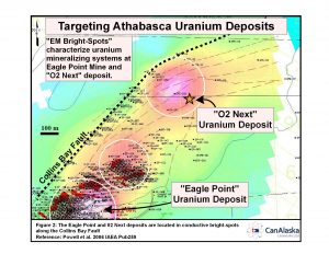
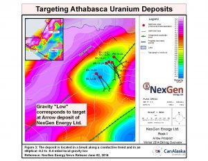
As the uranium-bearing fluids penetrate the basement rocks and interact with the graphitic metasediments, the development of a large alteration system usually occurs. These alteration systems can be mapped by geophysical methods such as electromagnetic (EM) and gravity surveys. In EM surveys, the anomalies may occur as bright spots representing an increase in respective clay development within the basement rocks. Such bright spots are known to occur near the Eagle Point mine and in part led to the discovery of the 02 Next deposit (Figure 2). In addition to enhanced EM signature, a gravity low would be expected due to the clay development and has been important in the discovery of NexGen’s Arrow deposit (Figure 3). Use of EM and gravity surveys to target along these linear faults is a critical step in exploring for basement-type uranium mineralization in the Wollaston Domain.
Historical Exploration
The project area was explored by various parties and most recently by Roughrider Exploration and Kivalliq Energy, and included soil and biogeochemical sampling, prospecting, EM surveys, gravity gradient surveys and magnetic surveys. Due to recent advancements in basement-hosted deposit understanding and limited post-Fukushima exploration activity, the project areas are considered vastly underexplored.
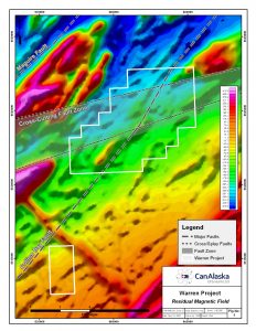
Warren Project
The Warren Project is located 20 kilometres northeast from the Watson Project straddling the interpreted Collins Bay Fault where the associated linear conductors are cross-cut by at least two east-northeast trending faults newly identified from historical magnetic surveys (Figure 5). These cross-cutting features also trend into the Burrill Project area to the west and the potential of this structural setting had not been recognized. As a result, no significant exploration has ever been completed in the Warren area.
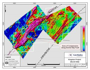
Kingston Project
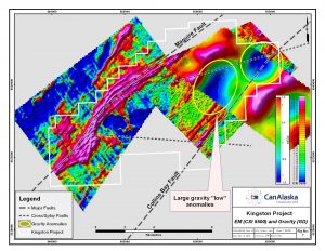
This project is located 10 kilometres northeast of the Warren Project along the interpreted location of the Collins Bay Fault. The Kingston Project also overlies the southwest extension of the Maguire Fault which has been drilled on CanAlaska’s Northwest Manitoba Project. In Manitoba, the Maguire Fault is associated with uranium enrichment and mineralization, and intense basement alteration similar in style to alteration observed in the Eagle Point area. The conductors associated with the Maguire Fault in Manitoba trend into the northwestern side of the Kingston Project and are spatially associated with anomalous lake sediment samples and a rock sample that returned 0.18% U3O8. Structural complexity at Kingston is indicated by the presence of several interpreted cross-structures and bending of EM conductors. Several gravity anomalies have also been mapped (figures 6 and 7). Neither conductor targets nor gravity targets have ever been drill-tested.
Watson Project
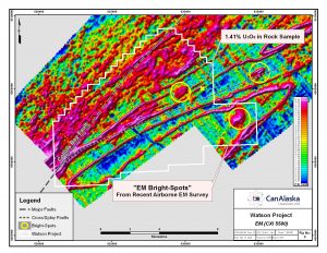
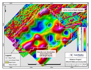
The Watson Project is located on a portion of a long linear conductor coincident with the interpreted location of the Collins Bay Fault where a conductive splay structure diverges from the main trend in a more easterly direction (figures 4 and 5). Coincident with this splay are previously defined gravity lows, electromagnetic (EM) “bright spots”, anomalous uranium-in-soil and biogeochemical samples, and an altered metasedimentary rock sample that returned 1.41% U3O8. These results appear to indicate the presence of uranium mineralizing systems that have not been drill-tested.
Burrill Project
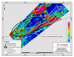
The Burrill Project is located 15 kilometres southeast from the Kingston Project covering the interpreted extension of the Maguire Fault and the cross-structures associated with the Warren Project (Figure 10). Strong EM conductors occur across the property in connection with the Maguire Fault trend and the east-northeast trending cross-cutting structures. The Burrill Project represents an area of interaction between conductor and fault trends and is coincident with anomalous lake sediment samples and uranium showings. This area has never been drill-tested.
CanAlaska Exploration
CanAlaska has been actively assembling datasets and modelling the data to provide focus for the resent claim acquisitions. This modelling work will continue and exploration targets will be further refined.
Potential
The NE Wollaston properties have the potential for discovery of Tier 1 basement-hosted uranium deposits similar to Cameco’s Eagle Point and Millennium deposits, and NexGen’s Arrow deposit. Generally, basement-hosted deposits do not reach the extreme high uranium grades seen at Cigar Lake or McArthur River, but have the advantage of being easier to mine because of better ground conditions, use of conventional mining methods, and a less stringent radioprotection environment.