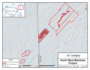
Location
The project lies in northwest Manitoba just east of the border of northeast Saskatchewan. It is 70 km north of Reindeer Lake and covers 143,603 hectares. The project has similar geology to areas which include the Rabbit Lake, Collins Bay and Eagle Point Uranium mines 90 kilometres to the South West.
Geology
The property is underlain by rocks of the Lower Proterozoic (Trans Hudson) age Wollaston domain. These supracrustal rocks are composed of psammites, pelites, graphitic pelites, calcsilicates and greenstones. These rocks rest on an Archean basement and are intruded by numerous small uraniferous pegmatites, and granite.
Exploration
Exploration was carried out in the 1960’s to early 1980’s by SMDC and several other companies and included detailed geological mapping, geochemical surveys and airborne geophysics. These exploration programs located uraniferous boulder trains, many conductors, numerous lake sediment, and radiometric anomalies.
CanAlaska commenced work in 2005 and carried out extensive exploration across the project until 2007. Exploration discovered numerous uranium, base metal and rare earth (REE) occurrences in boulders and outcrops. In mid 2007 exploration was put on hold pending community consultation by the Province of Manitoba. A 43-101 geological report filed in 2011 details ten areas for immediate drill testing.
In March 2012, the company received new work permits and commenced ground geophysical surveys. This work produced strong geophysical responses along a major structural corridor with associated uranium mineralised in boulders and outcrops. This includes massive pitchblende cobbles. Sheared and clay altered outcrops have also been observed along this corridor.
An extensive radon survey on land and lakes along the Maguire structural corridor by Northern Uranium in 2013 and 2014 defined a number of anomalies, some of which correlate with the earlier defined geophysical targets. Drilling started in late winter 2014.
Potential
Several outlier sandstone basins, such as the Reilly basin, indicate that the Athabasca Sandstone extends eastward beyond the present Basin. The potential exists for basement hosted deposits on this project, similar to Eagle Point or the Arrow deposit or the Kiggavik group of deposits in Nunavut. During the 1970’s and 80’s, the basement hosted model was not well understood and the source of the uraniferous boulder trains and anomalies were not located.
The Qualified Person for this overview is Peter Dasler. More detailed exploration information is available in the attached exploration news releases